THE PROJECT
Because excavating in Athens, no matter how expensive, is never without profit.
Stephanos Α. Koumanoudes, PAE 1869, p. 9.
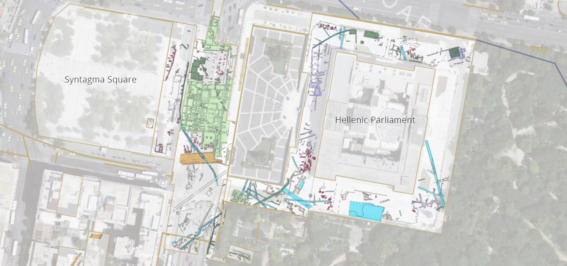
Our knowledge of the built environment of ancient Athens is primarily based on monuments preserved within archaeological sites, which are both well-recognized and extensively studied (e.g. the Parthenon and the Ancient Agora). But what was the fabric of the ancient city? What have large-scale public works excavations and the hundreds of smaller interventions on private plots uncovered? To shift the focus of research to the so-called rescue excavations and urban archaeology, Dipylon has created an original web platform based on open-source software to preserve and disseminate the fragmented archaeological wealth of Athens.
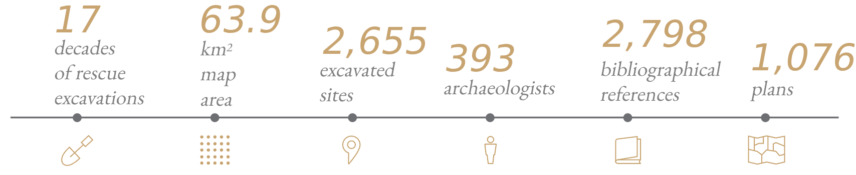
For the first time, archaeological data from all published rescue excavations conducted over the past 170 years in Athens, Piraeus, and the surrounding intermediate areas have been gathered and presented on a unified digital map. The bilingual (Greek/English) web platform offers combined search capabilities across data from 2,655 excavation sites, structured around two principal axes: a) the use of space, and b) the chronology of the remains (e.g. road network of Classical times, house of Hellenistic times, Roman baths). The archaeological data are categorized into 11 main historical periods, and their classification includes 12 thematic categories of space use, 63 categories of buildings and constructions, and 109 subcategories thereof.
The excavation sites comprising the digital map have been identified through cross-referencing multiple historical and cartographic basemaps, with the aim of ensuring their precise location. A total of 1,076 excavation plans have been georeferenced, vectorized, and then linked to the corresponding archaeological data. As a result, each archaeological find has been assigned its own spatial entity. Users can now correlate various types of archaeological data through spatial and chronological searches, covering a total area of approximately 63.9 sq. km of the urban fabric. The platform is regularly updated with new research data by keeping track of the publication of excavation reports in archaeological journals and conference proceedings.
The words of the English traveller Christopher Wordsworth often resonated in our minds; in 1836, following the track of time on Athenian soil, he wrote: “How much of labour, and perhaps of error, we might have been spared, had we been present but for a single minute at the Macedonian entertainment, at which the Athenian orator Dimades, when in Philip’s court, and when Philip asked him what and what sort of place Athens was, drew a map of it on the table where they were sitting”. And Wordsworth came up with the following sentiment, which expresses our thoughts perfectly: “But still of how much pleasure too, arising from this inquiry, should we then have lost also!”. (Christopher Wordsworth’s, Athens and Attica: Journal of a Residence There, London 1836, p. 179).
OBJECTIVE
Beyond the intrinsic value of recording scattered ancient remains, the project aims to situate these remains within a broader spatial framework. The ultimate goal is to understand their topographical context and gain a more complete perception of the urban development of Athens and the intermediate areas up to Piraeus.
The digital platform is specifically designed to enable specialists to efficiently manage the extensive volume of archaeological material. It also aims to provide easily accessible information about hidden antiquities to any interested citizen or visitor of the city.
Through this dual function, the platform aspires to support the work of researchers in the fields of archaeological and historical studies, as well as professionals in cultural heritage management and urban planning. At the same time, it seeks to raise public awareness about the city’s existing archaeological heritage.
The mapping platform also serves as a valuable educational tool for teaching historical topography across all levels of education. Its use brings to light previously unknown aspects of history and archaeology.
AREA COVERED BY THE MAP
During the first phase of the project (2018–2022), mapping covered 6.7 sq. km of urban space within the boundaries of the Municipality of Athens. This area corresponded to the part of the ancient city enclosed by the Themistoklean and Valerian Walls, along with a 500‑meter‑wide outer zone surrounding both fortifications.
According to a Delphic oracle transmitted by Herodotus (7.140), the ancient city developed around the Acropolis in a wheel-like pattern. In 479/8 B.C., the Themistoklean Wall encompassed the entire city (Thucydides 1.93.2). In the Roman period, a new fortification, the Valerian Wall, included a new eastern suburb that had meanwhile developed since the time of Hadrian, beyond the boundaries of the Themistoklean Wall.
In the second phase (2023–2025), the mapped area was expanded, covering a total of 63.9 sq. km. It encompasses regions northwest of the city center, reaching as far as Plato's Academy and the Kifissos River, and southwest toward Piraeus and Phaleron, along the axis of the Long Walls. The new limits cover the Municipalities of Athens, Piraeus, Moschato-Tavros, Kallithea as well as the Municipal Unit of Agios Ioannis Rentis. By expanding the mapped area, the project achieves a more comprehensive understanding of the city’s structure and function over time, from antiquity to the modern era, encompassing not only the urban center and its port but also all the intermediate areas of the Athenian plain.
CONTRIBUTORS
In designing and implementing the project Mapping Ancient Athens, Dipylon collaborated with philologists, archaeologists, cartographers, surveyor engineers and scientists specializing in databases, CAD and Geographic Information Systems, as well as visual artists. The main contributors are the following, in alphabetical order:
Konstantinos Chaidas (survey engineer, GIS specialist), Giorgos Chiotis (archaeologist, GIS specialist), Christina Giannakoula (archaeologist, GIS specialist, coordinator), Orestis Goulakos (archaeologist), Maria Karagiannopoulou (archaeologist), Markos Katsianis (archaeologist, GIS specialist), Matina Lampraki (surveyor engineer, GIS specialist), George Lampropoulos (mechanical engineer, GIS specialist) , Giorgos Panagiotopoulos (webGIS developer), Evi Sempou (philologist), Giorgos Sofianos (archaeologist), Katerina Stathi (historian, coordinator), Giota Taxiarchi (archaeologist), Aspasia Tsatsouli (archaeologist).
Marina Alexandri (creative director), Despina Alexandri and Robert Pitt (translation), Alexandros Christodoulopoulos (webMarker) and Kostas Ntagkas (Wave Web Ltd), Nikolina Koukouraki (geologist), Fred Ley (CAD specialist), Roberta Di Bari (architect), Chiara Mendolia (archaeologist), Alexandra Nikolopoulou (archaeologist), Jacobo Scoz (archaeologist), Thodoris Vakkas (Geospatial Enabling Technologies).
Lawyers Artemis Stampoulous and Christina Pigaki provided advice on issues of personal data protection and copyright, respectively.
The project was supervised by:
Leda Costaki (archaeologist), Vanda Papaefthymiou (archaeologist), Maria Pigaki (cartographer), and Anna Maria Theocharaki (archaeologist).
ACKNOWLEDGMENTS
Dipylon expresses its thankfulness to the following bodies for their kind permission to use and/or re-publish visual and cartographic material:
- Ephorate of Antiquities of the City of Athens
- Ephorate of Antiquities of Pireus and Islands
- Directorate of the National Archive of Monuments
- Hellenic Organization of Cultural Resources Development
- National Cadastre & Mapping Agency of Greece
- Municipality of Athens
- American School of Classical Studies at Athens
- British School at Athens
- French School at Athens
- German Archaeological Institute, Athens Department
- Italian Archaeological School at Athens
- The Archaeological Society at Athens
- The Academy of Athens
- Greek Epigraphic Society
- Museum of Cycladic Art
- Benaki Museum
- University of Thessaly Press
- University of Toronto Press
We warmly thank the Packard Humanities Institute, the Stavros Niarchos Foundation (SNF), the Aegeas Non-Profit Civil Company, and all the anonymous donors who recognized the importance of the project.
The project is under the auspices of the:
- Ephorate of Antiquities of the City of Athens
- Municipality of Athens
- Hellenic National Commission for UNESCO