DATABASE DEVELOPMENT
The database unit is the excavation site, namely, the site where archaeological remains have been located. This basic table is connected to others that pertain to interventions, architectural remains, visual material, and bibliographical references.
Data is stored in a PostgreSQL open-source database, utilizing the PostGIS extension to support spatial data management. The implementation was carried out by Geospatial Enabling Technologies (GET).
DESCRIPTIVE DATA
DATA LISTING
Information on the rescue excavations and their findings is derived from reports regularly published in issues of the Archaiologikon Deltion and other scholarly journals (Athens Annals of Archaeology, Praktika tes en Athenais Archaiologikes Etaireias, Archaiologike Ephemeris, To Ergon tes Archaiologikes Etaireias, Praktika tes Akademias Athenon, Annual of the British School at Athens, Bulletin de Correspondance Hellénique, Hesperia, American Journal of Archaeology, Mitteilungen des Deutschen Archäologischen Instituts, Athenische Abteilung) as well as proceedings of conferences. The web platform is constantly updated through the integration of data from newly published excavation reports.
The database includes even the smallest sections of immovable finds reported in publications, such as parts of buildings, cisterns, workshops, channels, and streets, representing all physical remains identified as evidence of the built environment at a specific time, as revealed through rescue excavations on plots, roads, median strips, sidewalks, squares, and other urban spaces; movable finds are not listed.
Based on the published archaeological material for the city of Athens, a bilingual vocabulary of semantic terms was created, compatible with acknowledged thesauri and dictionaries that support cultural heritage documentation, such as the Art and Architecture Thesaurus (AAT), the Forum in International Standards in Heritage (FISH) and the Dictionnaire méthodique de l'architecture grecque et romaine.
DATA CLASSIFICATION
Archaeological data on immovable finds from rescue excavations are organized to facilitate their management and use. This data is organized according to two main classifications: the first is typological, based on the function or use of space; the second is chronological, reflecting the historical period to which the remains belong.
The typological classification includes 12 thematic categories of spatial use (e.g., transportation, worship, defense), 63 categories of buildings/structures (e.g., road, sanctuary, curtain wall), and 109 subcategories (e.g., retaining wall, altar, staircase). For example, a section of an ancient road is classified under the class "transportation" and the category "road", with more specific subcategories accessible through the "Advanced Search" section of the platform.
The chronological classification of the remains is based on 11 historical periods of "macro-history" established in international scholarship (rather than strictly Athenian history). Thus, for example, a find dated to the 7th century AD is categorized under the Byzantine period (610–1453 AD), while dating in the specific century appears in the "Results" section of the platform.
The inherent difficulty of documentation, resulting from the fragmentary nature of remains uncovered during rescue excavations, often leads archaeologists to uncertain datings and identifications. When entering data into the database, no attempt is made to reinterpret information that excavators have reported, in order to preserve the integrity of the original source.
Excavation reports often provide indirect information (e.g., stratigraphy, associated finds) that define the lifespan of remains, frequently indicating either the earliest (terminus post quem) or latest (terminus ante quem) possible dates. Using the "Advanced Search" section of the platform, users can retrieve results related to the relative chronology of undated physical remains by enabling the filter "Supplementary results based on relative dating."
SPATIAL DATA
CARTOGRAPHIC BACKGROUNDS
The project spans 17 decades of continuous urban transformation in Athens and the intermediate areas up to Piraeus, with notable increases in the number of rescue excavations during periods of intense construction activity, such as in the 1960s and 1970s. This temporal depth necessitated the development of a multi-temporal cartographic framework in order to accurately locate excavation sites in both space and time.
To this end, various cartographic backgrounds are consulted and georeferenced on a case-by-case basis, all integrated within the Hellenic Geodetic Reference System (EGSA '87). Particular emphasis is placed on the use of the 2019 cadastral diagrams from the Hellenic Cadastre, which serve as the primary basemap for mapping excavation plots, georeferencing archaeological plans, and correlating them with the corresponding property units. The accuracy and level of detail provided by the modern Cadastre are essential for the precise spatial placement of archaeological remains within the contemporary urban fabric.
The main cartographic backgrounds employed include:
- Topographic diagrams of 1925 (Municipality of Athens)
- Pre-1936 topographic diagrams (Municipality of Athens)
- Topographic maps of 1974, photogrammetrically produced (Ministry of Public Works)
- Orthophoto maps of 2009 (National Cadastre & Mapping Agency of Greece)
- Cadastral diagrams of 2019 (National Cadastre & Mapping Agency of Greece)
IDENTIFICATION OF EXCAVATION SITES
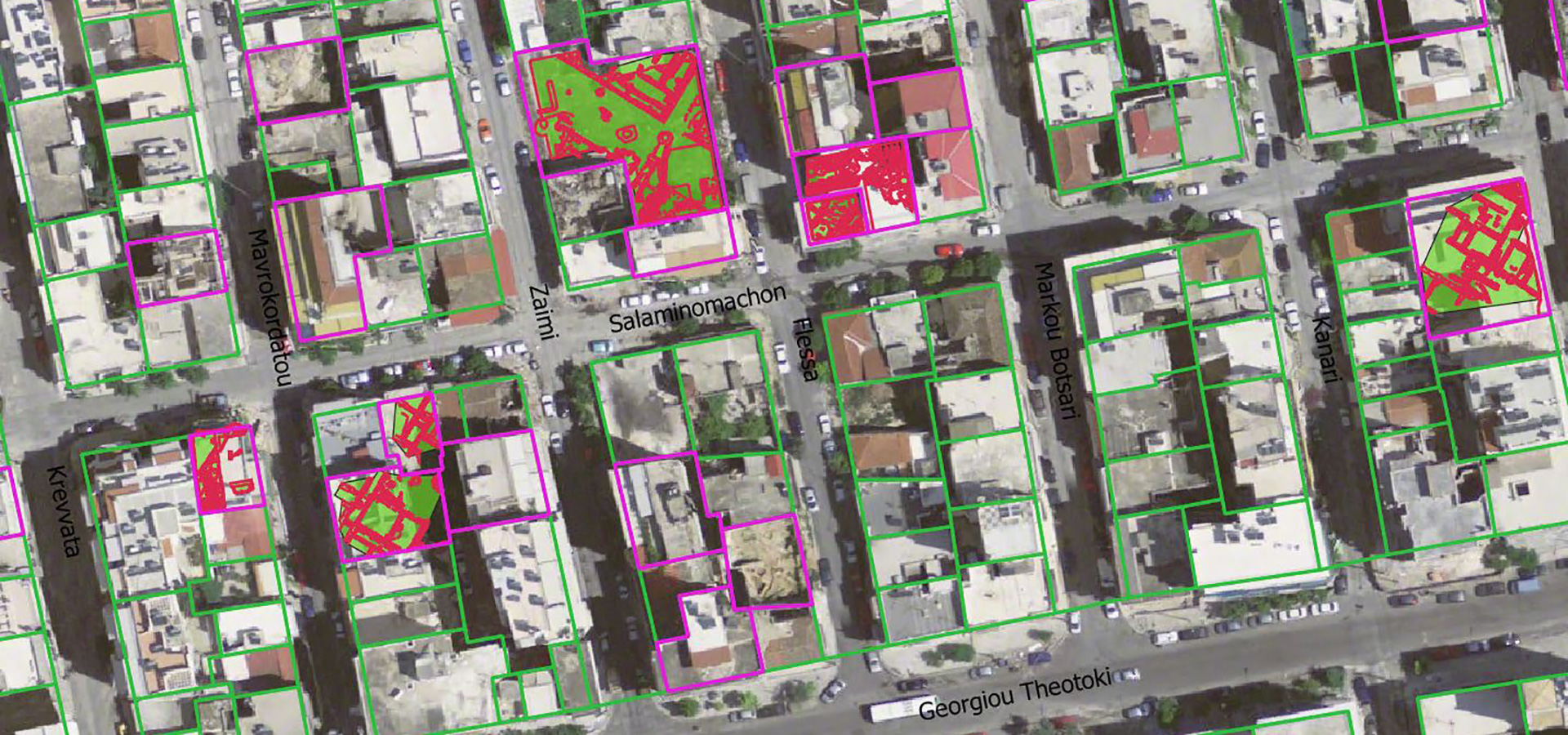
A primary task of the project is the precise identification of excavation sites. The plans published in the excavation reports of Archaiologikon Deltion are particularly valuable for this purpose. However, in cases where no excavation plans are included, which applies to as much as 65% of the reports, the only available indication of the location or area where the ancient remains were discovered is the excavation address.
Additional information, such as the proprietor’s name or the building’s construction date, along with an on-site autopsy, supports the confirmation of the spatial identification.
In the case of plots, the boundaries of the excavation site are delineated based on cadastral diagram data. For trenches along roads, such as those conducted within the framework of public works, the boundaries are represented by indicative rectangles.
GEOREFERENCING AND VECTORIZING OF EXCAVATION PLANS
In cases whereby an excavation plan accompanies the report, the plan is georeferenced and vectorized according to the following steps:
- Scanning of the excavation plan.
- Digital processing/preparation of the plan to be georeferenced
- Georeferencing of the plan based on the available cartographic backgrounds and as accurately as possible
- Vectorization of the plan – analytical drawing of the scanned file into a linear form
- Designing of the individual remains with polygon geometry
- Linking the aforementioned with the database
In cases of inadequate data regarding the identification of excavation locations (e.g., unclear address) or the georeferencing of plans (e.g., no scale, orientation, or plot boundaries), every possible effort is made to achieve greater accuracy to render the map thorough in terms of archaeological information.
Keeping detailed records of the precise identification of each excavation site allows for appropriate revisions should new data become available in the future.
DIGITAL CARTOGRAPHIC PLATFORM - webGIS
The digital map shows the association among the archaeological remains in the contemporary urban fabric and allows us to browse the excavations around the city. It provides the possibility of applying criteria for basic and complex searches regarding the general types of space use and the dating of the remains.
Our aim is to ensure both the scientific accuracy of the data and the usability of the digital platform, so that anyone interested, whether an archaeology enthusiast or a specialist in ancient topography, can easily access the data from rescue excavations.